
The Netherlands is experiencing striking Netherlands temperature differences this week, as a localized surge in warmth has pushed the mercury to 20 degrees Celsius in specific regions while much of the country remains locked in a cooler, more typical spring chill. This sharp thermal divide has created a fragmented weather map, leaving residents in different provinces experiencing entirely different seasons on the same calendar day.
For those in the affected warm zones, the jump to 20 degrees represents a welcome early taste of summer. However, for the rest of the nation, the contrast is stark, highlighting the volatile nature of the Dutch climate during the transition from spring to summer. This phenomenon is not merely a curiosity of the thermometer but a reflection of the complex interplay between the country’s unique geography and shifting atmospheric pressures.
Meteorological data indicates that these temperature spikes are concentrated in isolated pockets, likely influenced by specific wind directions and local land-use patterns. While a 20-degree reading may seem modest by global standards, in the context of the Low Countries’ unpredictable May weather, it marks a significant departure from the regional average, creating a “micro-climate” effect that varies from one city to the next.
The Geography of Variance: Why the Divide Occurs
The propensity for significant temperature gaps across the Netherlands is deeply tied to its physical layout. As a low-lying and remarkably flat country, the Netherlands is highly susceptible to the influence of maritime air masses. When warm air is pushed inland from the south or east, it often clashes with the cooler, stabilizing influence of the North Sea, resulting in the regional temperature variance seen today.
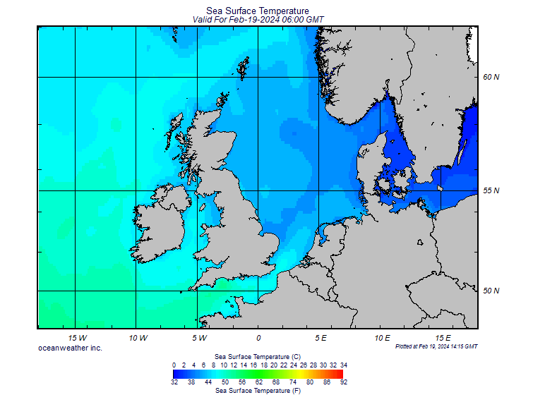
This atmospheric tension often creates “fronts” where warm and cold air meet. If a high-pressure system settles over a specific region—such as the southern provinces—while a coastal breeze continues to cool the west, the resulting temperature gap can be substantial. According to the Royal Netherlands Meteorological Institute (KNMI), the official authority on Dutch weather, these regional differences are common during the spring transition when the land warms up faster than the surrounding seas.
the “Urban Heat Island” effect plays a role in these spikes. Densely populated areas with significant concrete and asphalt infrastructure, such as the Randstad region, tend to retain heat more effectively than the rural polders or forested areas. This can lead to situations where city centers hit the 20-degree mark while the surrounding countryside remains several degrees cooler.
The North Sea Effect and Coastal Cooling
A primary driver of the current temperature disparity is the North Sea. The ocean acts as a massive thermal regulator for Northwestern Europe. In the spring, the water remains cold long after the land has begun to warm. When westerly winds blow, they carry this chilled maritime air across the coast, effectively “capping” the temperature in provinces like North Holland and South Holland.
When the wind shifts—perhaps to a southeasterly flow—the cooling effect of the sea is bypassed. This allows warmer air from continental Europe to flow unimpeded into the interior. The result is a scenario where inland regions can see the mercury rise rapidly toward 20 degrees, while coastal towns remain shrouded in a brisk, salty breeze that keeps temperatures in the low teens.
This duality is a hallmark of the Dutch experience. The proximity to the sea ensures that extreme heat is rare, but it also ensures that the transition to warmer weather is rarely uniform. The current weather pattern is a textbook example of how a slight shift in wind direction can transform a chilly morning into a mild afternoon for some, while others continue to reach for their coats.
Impact on Daily Life and Agriculture
These abrupt temperature differences have practical implications for both residents and the agricultural sector. For the general public, the variance makes dressing for the day a challenge, as a commute from a rural area to a city center can involve a temperature swing of several degrees.
In the agricultural sector, such fluctuations can be precarious. The Netherlands is known for its highly efficient greenhouse horticulture and dairy farming. While a rise to 20 degrees can accelerate plant growth, sudden swings back to cooler temperatures can stress certain crops. Farmers often monitor these regional variances closely to adjust irrigation and climate control systems within their facilities to protect yields.
the psychological impact of these “mini-heatwaves” is notable. In a culture where the weather is a primary topic of social conversation, the arrival of 20-degree weather—even if limited to a few regions—typically triggers a surge in outdoor activity, with terraces filling up and parks becoming crowded in the warm pockets of the country.
What to Expect Next
As the atmosphere continues to stabilize, the current temperature gaps are expected to fluctuate. The persistence of the 20-degree spikes depends entirely on the stability of the current high-pressure ridge and the direction of the prevailing winds. If the maritime influence strengthens, the warmth may be pushed out of the country; conversely, a continued continental flow could spread the warmth to the rest of the provinces.
Residents are encouraged to monitor real-time updates and local forecasts to stay informed about these rapid shifts. For the most accurate and up-to-date meteorological data, the public should refer to the KNMI official forecasts, which provide province-by-province breakdowns of expected temperatures and precipitation.
The next confirmed checkpoint for weather stability will be the updated weekly forecast released by the KNMI on Wednesday, which will indicate whether this regional warming is a fleeting anomaly or the start of a more consistent climb toward summer temperatures.
Do you have a temperature report from your region? Share your local readings and experiences with the current weather divide in the comments below.
Related reading