
On the windswept shores of Sable Island, a narrow crescent of sand drifting in the Atlantic off Nova Scotia, park rangers and archaeologists have uncovered the fragmented remains of a shipwreck believed to date back over two centuries. The discovery, made after years of monitoring shifting dunes and storm-exposed artifacts, has reignited interest in one of North America’s most notorious maritime hazard zones. Known locally as the “graveyard of the Atlantic,” Sable Island has claimed more than 350 vessels since recorded history began in the 16th century, its submerged sandbars and sudden squalls catching sailors unaware long before modern navigation aids.
The wreckage, initially spotted in February 2024 by a Parks Canada team member who noticed a pulley wheel stamped with British Royal Navy markings, was not immediately identifiable. Subsequent finds — including copper sheathing bearing broad-arrow stamps and an Admiralty mark dated January 1810 from Portsmouth — pointed toward the HMS Barbadoes, a British frigate refitted in England that year. Yet a larger section of hull, constructed from Bermudan cedar and consistent with a sloop’s size, suggested another vessel: the Swift, a civilian merchant ship en route from Bermuda to Newfoundland when it vanished in September 1812. The convergence of clues has led researchers to consider whether the site holds evidence of both ships, lost together during a violent storm that also claimed the schooner Emeline.
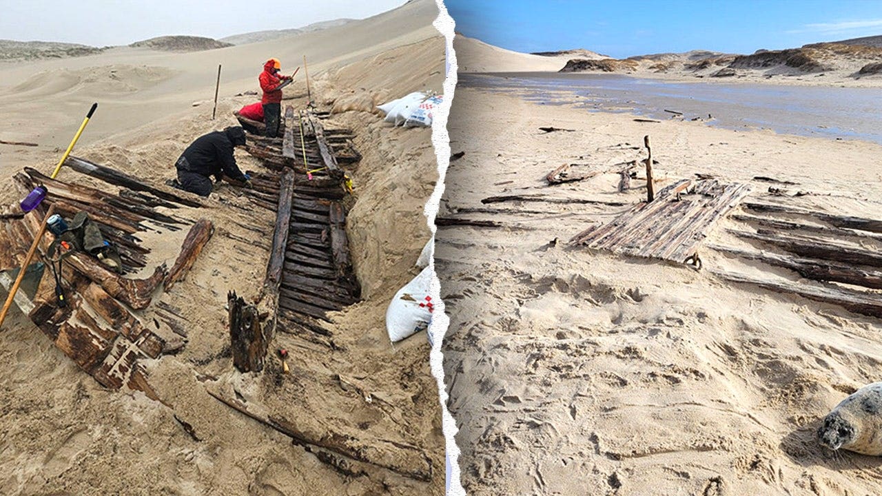
What makes this find particularly significant is not just its age, but its condition. Unlike most Sable Island wrecks — typically scattered, weathered fragments tossed in the intertidal zone — this discovery includes relatively intact structural elements buried inland from the current shoreline. Archaeologists noted the unusual scale and preservation during excavation, describing the wreck as “more complete than anything we’ve seen in decades of function on the island.” The find required careful adaptation to the island’s unstable terrain: teams used sandbags to stabilize excavation walls, employed skid steers to remove overburden without damaging artifacts, and finished with hand tools to expose fragile timber and metalwork before re-burying the site for protection.
Historical Context: The Loss of the Swift and Her Companions
To understand the potential importance of this wreck, it is necessary to revisit the historical record of September 1812. At the time, the Swift was a Bermudian-registered sloop engaged in trade between the Caribbean and Atlantic Canada — a common route for vessels carrying salt, lumber, and provisions. HMS Barbadoes, meanwhile, was a 20-gun post ship of the Royal Navy, tasked with patrolling the western Atlantic during the War of 1812. The schooner Emeline, though less documented, appears in colonial records as a private trading vessel operating out of Halifax.
According to naval logs and maritime insurance reports from the period, all three vessels were caught in a severe gale southeast of Sable Island on September 27, 1812. The Swift, lacking the reinforcement of a naval hull, is believed to have foundered quickly. The Barbadoes, despite her armament, struggled in the breaking waves near the island’s infamous sandbars. The Emeline, smallest of the trio, likely capsized or was driven ashore in the chaos. Although some crew members may have reached Sable Island’s beaches — known to sporadically cast up survivors — no comprehensive survivor accounts exist, and burial sites from the incident have never been formally identified.
Over time, the island’s relentless sand movement has buried and re-exposed wreckage repeatedly. What distinguishes this recent discovery is the combination of diagnostic artifacts: the Portsmouth-dated copper sheathing links directly to the Barbadoes’ known refit, while the Bermudan cedar hull aligns with Swift’s documented construction. No other recorded shipwreck in the region matches this precise confluence of materials, origin, and timing. Parks Canada archaeologists emphasize that while identification remains provisional, the evidence presents one of the strongest cases in decades for linking a physical wreck to a pre-20th-century maritime disaster on Sable Island.
Indigenous Collaboration and Archaeological Methodology
The excavation was conducted in partnership with Mi’kmaw archaeological technicians, whose involvement reflects a growing commitment to collaborative heritage management in Atlantic Canada. Parks Canada officials stated that Indigenous knowledge of coastal dynamics and traditional observation practices contributed significantly to interpreting the site’s formation processes. This approach aligns with updated federal guidelines on archaeology in culturally sensitive landscapes, which prioritize community consultation and shared stewardship.
Methodologically, the team faced unique challenges. Sable Island’s composition — over 90% loose sand with minimal vegetation — means that traditional excavation grids are ineffective; the substrate shifts constantly under wind and storm action. To counter this, researchers employed photogrammetry to create 3D models of exposed sections before removal, used GPS tracking to log artifact positions relative to stable dune markers, and implemented sandbag retaining walls to prevent collapse during digging. Once documentation concluded, the wreck was carefully re-covered with geotextile fabric and native sand to shield it from erosion and unauthorized interference — a standard preservation tactic for vulnerable coastal sites.
Dr. Matthew Betts, Curator of Archaeology at the Canadian Museum of History (who was not directly involved in the Sable Island dig but has studied regional shipwrecks), noted in a 2023 interview that “the real challenge isn’t finding wrecks on Sable Island — it’s knowing which ones matter.” He explained that the island’s sand acts like a giant sieve, sorting debris by size and density over time, which can scatter components of a single vessel across kilometers. “When you find a cluster of fastenings, sheathing, and hull planking still in association,” he said, “you’re looking at something unusually stable — a moment frozen before the sand took it all apart.”
Why Sable Island Earned Its Reputation
Sable Island’s perilous reputation stems from a combination of geography and meteorology. Located approximately 300 kilometers southeast of Halifax, the island sits on the outer edge of the continental shelf, where the Labrador Current collides with the warmer Gulf Stream. This convergence creates frequent fog, sudden squalls, and unpredictable sea states. Beneath the surface, submerged sandbars shift with each storm, forming invisible hazards that have torn keels and rudders from countless hulls.
Historical records from the Nova Scotia Archives indicate that between 1583 and 1947, over 350 vessels were reported lost in the vicinity — a figure cited by Parks Canada in public communications about the island’s hazards. These range from small fishing schooners to large immigrant packets and military transports. The island’s lack of natural harbors, combined with its featureless terrain, made rescue efforts extremely difficult before the 20th century. Shipwreck survivors who reached shore often faced days of exposure before discovery, contributing to the high loss of life associated with many incidents.
Today, Sable Island is a protected National Park Reserve, managed by Parks Canada in consultation with the Mi’kmaq of Nova Scotia. While shipwrecks still occur — most recently in 2018 when a fishing vessel ran aground during a nor’easter — modern GPS, radar, and coastal monitoring have drastically reduced casualties. The island’s current inhabitants are limited to rotating research teams, wild horse monitors, and occasional meteorological staff; its most famous residents remain the hundreds of feral horses descended from animals left behind in the 18th century.
Ongoing Research and Public Access
As of May 2025, the wreck site remains under active study, though no further excavation is planned for the immediate future. Parks Canada has stated that all recovered artifacts are being stabilized in a conservation laboratory in Dartmouth, Nova Scotia, where specialists are analyzing wood samples for dendrochronological dating and conducting metallurgical tests on copper fastenings to confirm provenance. Results are expected to be shared through a technical report later this year, with findings potentially presented at the annual Conference on Historic Site Archaeology in Halifax.
Public access to Sable Island is strictly regulated to protect its fragile ecosystem. Visitors must obtain permits through Parks Canada and typically arrive by chartered aircraft or vessel from Halifax. Guided tours are limited to designated zones to minimize disturbance to wildlife and archaeological sensitivities. While the wreck site itself is not currently included in public itineraries due to its ongoing study and re-burial for protection, Parks Canada occasionally shares updates via its official website and social media channels, including photographs of artifacts under controlled conditions.
For those interested in following developments, the Parks Canada Sable Island National Park Reserve page provides the most authoritative source of information, including seasonal access guidelines, research permits, and cultural resource management updates. The Mi’kmaw Heritage Trust also offers educational materials on Indigenous maritime history in the region, reflecting the deep ancestral connection to these waters that predates European settlement by millennia.
This discovery serves as a quiet reminder that beneath the shifting sands of Sable Island lie layered histories — of trade, empire, conflict, and survival — each tide revealing another fragment of the past. As analysis continues, the wreck may yet yield insights into early 19th-century shipbuilding practices, Atlantic wartime logistics, or the human stories of those who sailed too close to the island’s deceptive shores. For now, it rests where it was found: half-hidden, half-remembered, waiting for the next shift in the sand to tell more of its story.