
Communities across the Midwest and Great Lakes region are bracing for another round of severe weather following a night of destructive tornadoes that left widespread damage but no reported fatalities. Meteorologists warn that conditions remain favorable for additional thunderstorms, large hail, and damaging winds through the weekend, particularly in areas still recovering from Friday night’s outbreaks.
The National Weather Service has issued multiple tornado watches and severe thunderstorm warnings across states including Illinois, Indiana, Michigan, Ohio, and Wisconsin. Even as no deaths were confirmed from the initial storms, emergency crews continue to assess structural damage, downed power lines, and blocked roads in rural and suburban communities.
According to the Storm Prediction Center, a moderate risk of severe weather remains in effect for parts of the Great Lakes and Ohio Valley on Saturday, with the potential for isolated tornadoes, wind gusts exceeding 70 mph, and hail the size of golf balls or larger. Residents are urged to stay alert, have multiple ways to receive warnings, and avoid unnecessary travel during active warnings.
In the aftermath of Friday’s storms, utility companies reported tens of thousands of outages, with crews working around the clock to restore power. Local officials emphasized that while the absence of fatalities is fortunate, the scale of property damage underscores the importance of preparedness and timely sheltering.
Storm System Brings Widespread Damage Across Multiple States
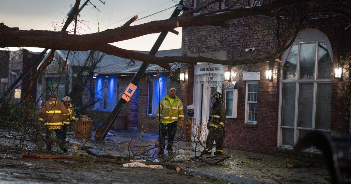
Survey teams from the National Weather Service began assessing damage on Saturday morning to confirm tornado occurrences and estimate intensity. Preliminary reports indicate that several long-track tornadoes may have touched down in northern Indiana and southern Michigan, with paths exceeding 10 miles in some cases. In St. Joseph County, Indiana, emergency managers described widespread tree damage, roof failures, and destroyed outbuildings, though no injuries were reported.
In Berrien County, Michigan, officials confirmed that a tornado damaged dozens of homes and snapped power poles along a rural stretch near Niles. The American Red Cross opened shelters in Benton Harbor and Niles to assist displaced residents, providing meals, blankets, and registration services.
Further east, in northwest Ohio, Lucas County emergency management reported damage to agricultural structures and grain bins in rural townships west of Toledo. The Ohio Emergency Management Agency stated that no state of emergency had been declared as of Saturday afternoon, but local jurisdictions were coordinating damage assessments.
All reports emphasize that while property damage is significant, the lack of fatalities is attributed to timely warnings, public awareness, and the nocturnal timing of some storms occurring in less densely populated areas.
Severe Weather Threat Persists Into Saturday
The Storm Prediction Center’s outlook for Saturday indicates a continued risk of severe convection across the eastern Corn Belt and lower Great Lakes, driven by a strong mid-level jet and lingering instability. Forecasters note that while the primary threat may shift slightly eastward compared to Friday, the potential for supercell thunderstorms remains.
Meteorologists at the National Weather Service office in Northern Indiana highlighted that wind shear profiles remain favorable for organized storm development, particularly in the late afternoon and evening hours. They advised residents to treat any thunderstorm warning seriously, even if not explicitly labeled as a tornado threat.
Emergency management agencies across the region are maintaining heightened readiness, with some counties pre-positioning response teams and alerting volunteer groups. The Federal Emergency Management Agency (FEMA) Region 5 office in Chicago stated We see monitoring the situation closely but has not yet been requested for federal assistance.
Utility providers including Indiana Michigan Power and Consumers Energy reiterated their commitment to rapid restoration, noting that mutual aid crews from neighboring states are en route to assist where needed. Customers are encouraged to report outages through official apps or websites and to avoid approaching downed lines.
How to Stay Safe and Informed During Ongoing Threats
Public safety officials continue to stress the importance of having a severe weather plan, especially for those in mobile homes, campers, or structures without basements. The National Weather Service recommends identifying a safe shelter location in advance—such as a basement, interior room on the lowest floor, or community storm shelter—and practicing the plan with household members.
Residents are encouraged to enable Wireless Emergency Alerts (WEA) on their smartphones and to apply NOAA Weather Radio for reliable, real-time updates, particularly during overnight periods when cell service may be compromised. Local television and radio stations, along with trusted national sources like the Weather Channel and AccuWeather, are providing continuous coverage.
For those seeking official updates, the National Weather Service maintains county-specific forecast pages at weather.gov, where users can enter their location to view active warnings, radar, and hourly forecasts. The FEMA app likewise provides weather alerts and shelter locations.
As the region remains under a heightened threat level through Saturday evening, officials urge the public to remain vigilant, avoid rumor-driven social media posts, and rely on verified sources for critical information. The next update from the Storm Prediction Center is expected later today, with any changes to risk levels communicated promptly.
Stay informed, stay prepared, and gaze out for one another. If you have storm photos, damage reports, or safety tips to share, we encourage you to comment below or share this article to help keep your community aware.